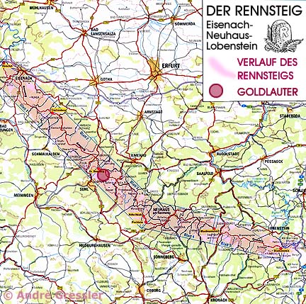
Goldlauter lies on the southwest slope of the Thüringer Forest in the heart of Germany. The Große Beerberg is the highest point in the Thüringer Waldes. It is located only three kilometers from Goldlauter and even falls within the Goldlauter Corridor! The Rennsteig is the highest and probably best known German trail in the Thüringer Forest and provides beautiful views of Goldlauter-Heidersbach to the hiker.
Where today flow the rivers Ramselbach, Goldene Lauter, Lange Lauter and Dürre Lauter, there was once located 290 million years ago an underwater basin which has left behind a deep valley. And whether one wants to believe it or not, in this inland sea about 40 km wide even sting sharks lived in abundance! In the upper part of the valley, one can still find today impressions of fossil fishes or even the little stingers of the sharks.
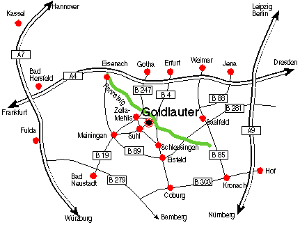
The best way to get to Goldlauter is simply to input your hometown on the pages of the trip planner website Reiseplanung.de and as the destination "Goldlauter". The Postal Zone of Goldlauter is 98528. Thereupon you receive a detailed itineary. You can then look at and/or even print out the trip route and the desired country maps. A really cool internet service!
Or download for yourself an outline of the town of Suhl in the PDF format.
If you are an "Ausländer":
Lonelyplanet World Guide: A good information source about Germany
or
Yahoo
Starting Point Germany (incl. immediate Exchange Rates)
Geography
![]() Truth about Woppers
Truth about Woppers
![]() Village Chronicle
Village Chronicle
Woppers in Amerika
![]() Musical greeetings from Goldlauter
Musical greeetings from Goldlauter
![]() Famous Wopper
Famous Wopper
Impressions from Goldlauter
![]() Vacation in Goldlauter
Vacation in Goldlauter
![]() Different
Different
HOME